The Photographic Resource Center is currently presenting a show in conjunction with the Boston CyberArts Festival calledLand/Mark: Locative Media and Photography through May 5th. The show includes four photographers (one of whom is actually an anonymous collective), and it describes the increasingly complex web of relationships between imagery, mapping, location and experience. Though visually divergent, the work shares a fusing of traditional photographic practices with evolving digital mapping technologies. While not necessarily landscape photography in the traditional sense, the images innovatively re-imagine and enliven the essential concept of landscape: the relationship between the space within oneself and the space of the world.
Josh Winer’s large-scale color prints depict enormous rolling piles of dirt, rocks, or salt, with small patches of sky peeking out from behind the mounds. They are nameless shapes that fill the frame of the photograph, squeezing out any other identifying information. In place of titles, we are given only the GPS coordinates of the location. The images are meant, according to Winer, to talk about the darker side effects of urban development: “We construct and demolish not only buildings but also the very foundation of the earth itself. We mine, tunnel and move mountains with seeming impunity.” The horizontal composition and sharp focus situate these images within photography’s landscape tradition, but the subject matter’s marginal status, combined with the minimal GPS information, raise deeper questions about the way societies order their public spaces, the aesthetics of refuse, and even the possibility of photographing nothingness.
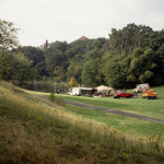
The evolving phenomenon of Geocoaching is the ostensible subject of Margot Kelley. Geocaching is an internet-era version of the treasure hunt; wherein someone hides a small box of items and posts the GPS coordinates online. (Since GPS gives a small margin of error – roughly a 20-foot circumference – finding the cache can still be a challenge.) A wide community of people log on, download the coordinates, and set out to find someone else’s treasure, and Kelley is one of them. The images here, 16x20” color prints paired with her written recollections, depict places Kelley found as part of her geocache travels: a dock at Lake George, a new housing development in Nevada, a local park in Malden. What distinguishes Kelley’s work is the methodology that the Geocaching game imports to her travels: it makes relevant to the images the questions of what happened to her on her way, what was at the place other than what’s depicted in the image, who was with her, how she found it, or why it struck her as choiceworthy to photograph. Unlike, say, Stephen Shore or Joel Sternfeld, Kelley isn’t wandering aimlessly across the continent, but rather is looking for something specific in each journey, something left there for her to find. Kelley’s inclusion of personal narrative in the exhibit also marries those landscape traditions to those of personal, vernacular photography too, and in reading them we realize that, as with all journeys, the traveling itself is the most important experience. (In fact, some of the geocaches only mark out a certain scenic view or notable object, or perhaps contain only a written nugget of wisdom.)
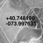
Brooke Knight’s photographs and video installation depict most clearly the direct correspondence of GPS mapping and the demarcations of our daily lives. In one set of prints, Knight has photographed the sidewalks in front of various New York City landmarks and superimposed on the image the GPS coordinates of the location. The various types of material in each sidewalk bear a striking resemblance to their parent structures: the familiar steps of the Metropolitan Museum or the pearlescent Art-Deco swirls at the foot of the Empire State. By staring at the ground and not, in fact, the building itself, Knight demonstrates that landmark is just a concept, a set of coordinates on a map; any place could be a landmark. The other photographs are images of the sky paired with charcoal traces of the ground at the spot the sky image was taken; they are specific locations, and the four of them all mark out a square around downtown Boston. His frenetic video piece, entitled Every Environment is Text Rich #2, is footage of the same New York landmark locations, but the camera movements are spelling out the title of the piece.
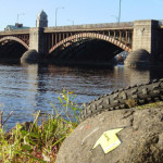
Yellow Arrow, the name given to the “global public art project of local experiences”, is an astounding and innovative merger of photography, culture, travel, cell phones, graffiti, architecture, urban aesthetics, blogs, chatrooms, globalization, and public meeting spaces. Internet technology is here a cure for alienation, not a cause. Basically, one can place a small yellow arrow sticker on something notable in the world, then send a text message with personal thoughts on the reason for stickering the thing to a coded telephone number. Then, whenever someone else encounters that yellow arrow sticker, they send their own text message and in return receive the first message sent by the person who placed the sticker. The exhibition features dozens of photographs of yellow arrow stickers in various scenes, each accompanied by the original text message that came with it. Yellow Arrow takes a basic premise of photography – that it can transport you to a location where you actually aren’t – and draws out its logic: now you can be in the photograph that you saw. Technology is here reshaping our lived experiences, and our connections to the lived experiences of others.
At the heart of this show is the dual nature of locative media. In Winer or Knight’s hands, it makes place so specific that it becomes anonymous, while for Kelley or Yellow Arrow, the technology upends anonymity by creating social connections and site-specific relevance for a given location. Ultimately, this work makes the idea of location itself meaningful, not just the places that inhabit those locations. Knowing where we are is an important question, but so is how we got there, and so is what we tell people about it later.
- Brooke Knight, from Landmarks series, Empire State Building, inkjetprint, 1999
- Margot Kelly, N 42 ° 25.785 W 071 ° 05.008, C-print mounted on aluminum, 2002
Links:
Photographic Resource Center at Boston University
Boston CyberArts Festival
GPS resources
Geocoaching
Glowlab
Yellow Arrow
Land/Mark: Locative Media and Photography is shown in conjunction with the Boston Cyber Arts Festival and is on view at the Photographic Resource Center located at 832 Commonwealth Ave., Boston until May 5th.
All images are courtesy of the artists the PRC.

