
Bruce Myren’s The Fortieth Parallel is a project of western depiction. Rooted in history, it takes cues from historic survey projects and their subsequent rephotographic cousins, Ed Ruscha’s explorations of buildings on Sunset Strip and the New Topographers’ unromantic views of the west. It is an exploration of how to picture the land when the land has already been pictured: a conversation with the past designed to teach us about our present.
Myren began to think about the invisible lines that circle our earth at five years old when his father, a surveyor and engineer, used Star Trek references to explain the concept of longitude and latitude. This put the idea of the world’s entirety and our relationship to place into context, sparking a new way of seeing for Myren. Subtle clues within the land itself, such as pavement changing on the roads between towns, illuminated spatial separations.
This relationship to place is forefront in Myren’s work: we see it in his photographic explorations of Fort Juniper and in his project Markers: Memory. And, most prominently, we see it in The Fortieth Parallel. Expanding on this childhood experience, Myren became interested in travelling this imaginary line through a chance encounter with a friend in 1991 while hiking Flagstaff Mountain. Noticing the road they travelled to get there—Baseline Road—ran east in a straight line as far as they could see, Myren inquired if his friend knew why. This road was the 40th Parallel, a key marker in the exploration of the west and a line used to delineate townships and homesteads. Just as he searched for visual clues of differentiated space as a child, The Fortieth Parallel, spawned from this experience, searches for visual markers within this invisible line. From 1998 to 2012, he has photographed each whole degree longitude on the 40th degree of latitude north, creating triptychs with his 8x10 Deardorff camera. The project culminates as 52 images, one for each of these sites, approximately 53 miles apart, across the continental United States.
The resultant project shares obvious ties and connections to its historic counterpart, the images made by Timothy O’Sullivan in conjunction with the geological survey of the 40th Parallel by Clarence King. The U.S. Geological Exploration of the Fortieth Parallel studied west of the 100th meridian in 1867. Funding was governmental, fueled by potential commercial gain (for the expansion of the transcontinental railroad) as well as scientific advancement and military control. Timothy O’Sullivan, ultimately a hired gun and an agent of Clarence King, was brought along to document the survey’s findings. His primary role was that of documentarian: the vision and artistic merit revealed through his photographs was secondary.1
O’Sullivan’s images speak about the topography of the land. Vast and barren, dry and unforgiving, they beseech the commercial appeal of landscape painters working at the same time. The focus is sharp. It reveals each unforgiving rocky outcropping on mountains and the individual leaves of scrub brush. It speaks to the land as unsustainable. Sometimes, such as in the case of Lake Lall, Uinta Mountains, Utah, O’Sullivan moves his camera to capture multiple frames of the same view: a diptych. In others, such as Echo Cañon, Utah the camera moves closer like the zoom of moving images. With subtlety, their tones reveal undulating land, while figures speak towards scale. The images have understandably passed into the realm of art history. But, at the time of their making, they functioned as scientific documents, taken with painstaking care as revealed through careful compositions and framing. Both historic and historical, today they educate us about what the land once was. But in the nineteenth century, these photographs were active documents revealing relatively unseen territory.
Surveying the land was not new. Photographic surveys in the nineteenth and twentieth centuries merely expanded on what had been an exploration strategy throughout history. Alongside the Geological Exploration of the Fortieth Parallel, other governmental excursions studied additional westward territories: William Henry Jackson was the official photographer for the 1871 Yellowstone survey with Ferdinand Hayden2 and Alexander Gardner looked at Northern Arizona across the 35th parallel from 1867 to 1868.3 Later, the Rephotographic Survey Project remade iconic western photographs by Timothy O'Sullivan and William Henry Jackson,4 and the New Topographics looked with banality at what ultimately became a man-altered landscape.5
Each new survey project exists in conversation with its predecessors and Myren’s contemporary investigation is homage to them all, though linked through its title to the Clarence King and Timothy O'Sullivan survey. The former provides the conceptual framework for the latter, but it departs from there: it is not a rephotographic project. O’Sullivan was an operator, but Myren is both researcher and artist. He has set up a project informed by the history before him that expands to reveal a new vision.
This vision is influenced by the ability to geo-locate with specificity. Despite early attempts in the project to locate the confluences with maps, Myren’s The Fortieth Parallel did not begin until handheld GPS was available. At each site, there is a 20 square foot area in which the GPS still reads as zeros, the determining factor of where the confluence is. Within this spot, choices are made visually. The Deardorff camera is bulky and large: it necessitates viewing. The experience of looking, sometimes for minutes, sometimes upwards of an hour, is revealed within the images themselves, which show obsessive dedication to his project. The choice to make three pictures that ultimately exist as one, in the form of a triptych, expands each location beyond the narrow view of one photograph, beginning to replicate the field of vision a typical person may have.6
Careful and concise, the triptychs emphasize a varied view of America, revealing an absurdity about what is located on each spot that makes up this historically relevant contour. Each picture is a view of the everyday, made of whatever happens to be on location at the time of its making. What are ordinary changes as we move from east to west, however, exposing cultural and geographic differences in both the land itself and how it is occupied. We see the artist respond to each location separately, evidenced by formal decisions to allow the horizon line to change from image to image. Human presence on the land is visible in most. This point, driven home by power lines, roads, buildings and manicured fields, is underscored by the presence of the photographer. In order for the photograph to exist, a human had to take it. Devoid of people, they beg the question (and then subsequently answer it): can we evidence people without showing their bodies?
At each end of the project, we see the coast: one Atlantic, the other Pacific. In between, the landscape progresses from more populated in the easterly shots to more wild in the westerly ones. N 40° 00’ 00" W 83° 00’ 00" Columbus, Ohio, shows the land presently occupied by people: brick buildings (one presumably a house, the others apartment buildings) stand next to a yellow house. The architecture is broken by the frame lines: we are acutely aware of the camera shifting from frame to frame. No one is visible, but people are present. As we move from triptych to triptych, shifts in the horizon break what could be potentially formulaic compositions: in N 40° 00’ 00" W 104° 00’ 00" Hoyt, Colorado power lines reveal the land as worked across a consistent horizon line that differs from the shifting architecture in the former image.
When printed, the film frame remains as part of the image; as both a holdover from contact printing to corroborate full frame composition and as a visual signal of the photograph as an object separate from the its pictured contents. The frame lines denote the passage of time to emphasize the experiential nature of the work. Lettering and notch codes on the sides reveal the film it is shot on: Kodak Ektachrome Professional Plus 100 (EPP 100), an American color transparency film.7 Using color chrome film that is later scanned and output digitally separates this work from the black and whites of the New Topographics and early western photographers such as O’Sullivan himself. Myren’s photographs are not straight documents of places or grand illusions. Instead of picturing the sublime as his forerunners did, they are in dialogue with it as a response to the idea of the west as wild and untamed.
While always in concert with these early western photographers, Myren’s project holds ties to other, more contemporary, modes of image-making and thinking as well. Ed Ruscha’s conceptual strategies, especially in projects such as Every Building On Sunset Strip, inform the project structure: a set format, with locations determined by scientific and conceptual information. Ultimately, Myren’s decision to make the best picture in a particular spot, instead of following a formula, separates the two artists and allows The Fortieth Parallel to speak towards Ruscha’s work without becoming a riff on it.
Each image is titled with both the name of the town it was taken in and its geographic coordinates, prompting viewers to match visual information within the pictures to locations determined by numerical degrees. This exercise in understanding our experiential knowledge of a place simultaneous to its position on the globe looks towards our relationship between body and technology. In a geo-specific world, where we are constantly orienting ourselves via cellphone app or car GPS, do we really know the connection between the lines on the map and where we stand? Myren’s photographs prompt realizations of the subsequent disconnect, forcing us to look closer at our assumed knowledge of locales.
While GPS has been an integral aspect of Myren’s process, acting as the final locating device for confluences, traditional maps are the primary method of finding each site. Often, a Google map with bullet points to highlight each confluence is included in literature surrounding The Fortieth Parallel to help viewers understand the interconnection of photographs and titles. Over the course of the work, a project map has also given the artist himself a sense of place in which to locate the images. Thus, Myren’s pictures are ultimately derived from maps, while O’Sullivan’s pictures became one.
Myren’s images reveal that O’Sullivan, while primarily an operator and data collector, also must have had an ulterior motive to express his own experiences. His work was that of an editor selecting particular views to preserve in collodion, but the vast and arid images reveal a vision: unfettered and bleak, but a vision nonetheless. Myren's images, however, are more favorable towards the land and have accomplished something that his forerunners missed: it illuminates an experiential understanding of place, looking at specific locales to prove the ultimate ubiquity of the American landscape. His pictures show that despite advances in technology, the only way to understand the land is to look at it. And, through his project, we are allowed to do just that.
-
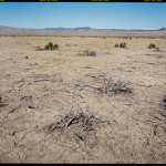
- Bruce Myren, N 40° 00’ 00″ W 117° 00’ 00″ Battle Mountain, Nevada, 2012
-
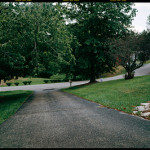
- Bruce Myren, N 40° 00’ 00″ W 82° 00’ 00″ North Zanesville, Ohio, 1999
[1] Williams, Carol J. Framing the West: The Survey Photographs of Timothy H. O’Sullivan. Oxford University Press, 2003. 17.
[2] Merrill, Marlene D. Yellowstone and the Great West: Journals, Letters, and Images from the 1871 Hayden Expedition. University of Nebraska press, 2003.
[3] Babbitt, James E. "Surveyors Along The 35th Parallel: Alexander Gardner's Photographs of Northern Arizona, 1867—1868." The Journal of Arizona History. 22, No 3. (1981): 325-348. Accessed June 26, 2013. http://www.jstor.org/stable/41695613
[4] For more information, see Second View: The Rephotographic Survey Project. Klett, Mark and Ellen Manchester and JoAnn Verburg. Second View: The Rephotographic Project. Albuquerque: University of New Mexico Press, 1984.
[5] For more information, see Reframing the New Topographics. Foster-Rice, Greg and John Rohrbach, eds. Reframing the New Topographics. Chicago: Center for American Places at Columbia College, 2010.
[6] Vanhemert, Kyle. An Obsessively Precise Portrait of a Lattitude Line, From Sea to Shining Sea. Accessed June 26, 2013. http://www.fastcodesign.com/1671211/an-obsessively-precise-portrait-of-a-latitude-line-from-sea-to-shining-sea#10
[7] Myren states that using an American-made film is essential to the project: it provides another layer of exploration of what is inherently American. Stucker, Hal. A Parallel Life. Accessed June 26, 2013. http://digitalmag.pdnedu.com/pdnedu/spring2013#article_id=264853


